The Ghost Stones
The distant hills of Gyrn
Goch and Gyrn Ddu with Tre Ceiri Hill Fort in the middle distance taken from
the summit of Yr Eifl.
The Lleyn Peninsula has me in a draw, I have
recently rediscovered how wonderful the landscape is and how easy its
accessibility is too, despite the rather jaw dropping fact that if you lived at
the tip of the peninsula at Aberdaron and required medical attention in Ysbyty
Gwynedd, it being the local hospital, it entails a journey of 42½ miles by road
and can take up to one and a half hours, or ten minutes in a 22 Squadron Seaking
helicopter, a pleasing though if you are ever in need of emergency aid, but it
does make you think that you are rather in isolation.
The trip had already been aborted three times
before a success was finally achieved, the first attempt ended almost where it
began, I had planned a trip to climb Gyrn Ddu and Gyrn Goch, two small but
deceptively steep hills whose flanks tumble into the sea via Clynnog Fawr and
Trefor. I had passed their bases more times than I can remember but had never
explored the tops, they had never been that high on my tick list for some
reason despite being so close to home, but a trip up to the iron age Tre Ceiri
Hill Fort on the Rivals with my friend John drew me to them as they bathed in
the sunshine in the crystal clear light, I had used Google maps to have a look
at the terrain as I often do these days if I am planning a trip and it revealed
a fascinating landscape with some interesting rock formation and several
prehistoric remains.
I had been given a small volume that my friend
John Cantrell had published on walks in the Lleyn Peninsula
and the circuit around these two peaks looked like a nice afternoon jaunt.
1st Attempt.
I parked on the old road at the village of Gyrn
Goch and set off rather in haste and without reading John’s description in
detail, I remember the text mentioning a path up the left hand side of the
conifer plantation so I duly set off at a fair pace and took the left fork in
the track as described, I followed the river for a short while and got to
thinking that the path although very distinct was not much used, after a
struggle to cross the river via some very greasy boulders I was confronted with
chest high bramble and ferns, fighting my way as best as possible in Dr
Livingstone style I quickly got the impression that my way was not the right
way, by now the path was virtually nonexistent, up ahead I could see a dry
stone wall and what looked like a 5 bar gate so I continued my struggle, I
eventually reached my goal and my ears were filled with heavy breathing, I knew
I had struggled through the undergrowth and had just joined the ‘bus pass’ set
but I wasn’t that unfit surely, I reached the top of the wall and looked over
it only to be greeted by a large mouth full of huge teeth wide eyes and
nostrils that were snorting at me rather menacingly, I was face to face with a
woolly faced alpaca, in fact the field was full of them, also rather weirdly,
in the middle of the field was a 1960’s Triumph Herald. It had also started to
piss down. A strange Pythonesque feeling came over me as to how unreal it all
was, I turned turtle and headed back the way I came through all the ferns and
brambles, to top the day my boots were leaking too, not a good day.

My rather wet and snarly
friend
2nd Attempt.
Now I was laughing, I had checked my maps and
reread John’s description, in one of the chapters to the walk he mentions a
100ft waterfall that tumbles from the edge of the cwm, this waterfall has kept
itself a secret as far as I could make out, I asked several of my colleagues
who were regular mountain walkers if they knew of this cataract hiding amongst
the trees, nobody had heard of it and there didn’t seem to be any mention of it
anywhere either so off I set once more. This time I at least found the right
start and set off up the farm track
The BBC weather forecast was not promising too
good a day but what the heck, nothing ventured etc,
I got as far as the forest clearing and the
heavens opened, but I could hear the roar of the elusive waterfall so carried
on, the track now became nonexistent and I found myself heading towards the
falls, after what seemed an age I caught a glimpse of it through the downpour and the dense
undergrowth and decided that they would have to wait for another day, I was now
at the wall which leads to the open countryside and the hills beyond so I
decided to at least make a low level round trip by returning along the old wall
that acts as a boundary to the woodland. The hills beyond had long ago vanished
into the mist and it was getting wetter as the day progressed. The path was
very wet, very boggy, it was still pissing down and my boots still leaked.
Soaked and rather dejected I headed for home.
3rd Attempt
My wife Clare gave me one of those looks that
says it all without actually saying much at all, not the bloody waterfall
again, don’t bother it’ll rain anyway.
I had tried to convince her and myself that these
trips to the Lleyn were a much better proposition at this time of year than
heading for the higher hill of Snowdonia, I had regaled her with amazing facts
that Snowdon can average 200 ins of rain a year but the Lleyn only averages 37
ins a year, so the law of averages had to be on my side, --- she laughed.
I set off once more and this time headed in a
slightly different direction by heading into the woodland itself along the
workers track which followed the stream and hopefully the waterfall too, this
time I met a man and his dog, the first sign of any form of life I had
encountered on my trips so far, the dog, a huge American mastiff eyed me up and
sniffed about rather alarmingly, I fell into conversation with the owner who
said, ‘he’s gentle enough, don’t worry’, (they all say that, or “he doesn’t
bite” don’t they). The rope that the dog was attached to was thick enough to
hold a trawler steady in a storm, always a worrying sign; any animal that needs
to be linked to a hawser should be in a cage!! It turned out during our brief
conversation that he had only had the animal two days and was getting it used
to its new territory, hmmmm
I was carrying a black Manfrotto tripod which
does rather resemble a rifle if you carry it across your chest, so the beast
might have thought we were off to hunt Moose or whatever American mastiffs
hunt.
I bade him and his dog, which was now leaning
against my legs and looking at me wistfully as if we had been hunting buddies
all our lives, a good day and set off in search of the cascade.
After about ten minutes I was having second
thought about my plan to thrash my way through the bracken and laurel growth
and a lot of horrendously wet and slippery ground just to find the falls but I carried
on regardless, eventually after much grunting and more Dr Livingstone style
jungle bashing I found it, well sort of found that is—by hanging off the trunk
of a laurel bush I could see the top third of it as it tumbled into the steep
sided valley, at least it did exist but getting to it was nigh impossible and a
tad risky too, to top it all it started to piss down and my boots were still
leaking.
I carried on upwards and did the usual low level
round trip and lo and behold the rain became a drizzle and eventually just a
slight dampness, on the descent past the forest I came across the remains of an
old medieval field system and the tumbled rocks of some dwellings which were an
added bonus to the day.
I took a few shots on the camera and headed back
to the car, I was getting well acquainted with the area by now.
The remains of the
medieval field systems on the lower slopes of Gyrn Goch
4th Attempt
Even I was getting a bit fed up of trudging up
the forest path to gain the open moor but at least it wasn’t raining, yet!!
Once more I headed up the track and gained the
boundary wall and headed for the summit of Bwlch Mawr and after a good brisk 20
minutes I was on the summit, It was from this top that the landscape opened up
and I was amazed how bleak and open the vast expanse of moor actually was, to
think it was only a short distance from the road it felt like being in the
middle of the Carneddau. From here you can make out the dry stone walls which
are an incredible feature of this area, they literally extend for miles in all
directions, are all in extremely good condition and are as straight as a die,
apparently they were erected early in the 19th Century by the
workers who were employed by Lord Newborough** whose estate covered a vast area
of the Lleyn and beyond, the amount of rock that has been moved in this very
open and exposed bit of moor to create these walls is mind boggling as is the skill
and quality of the workmanship.

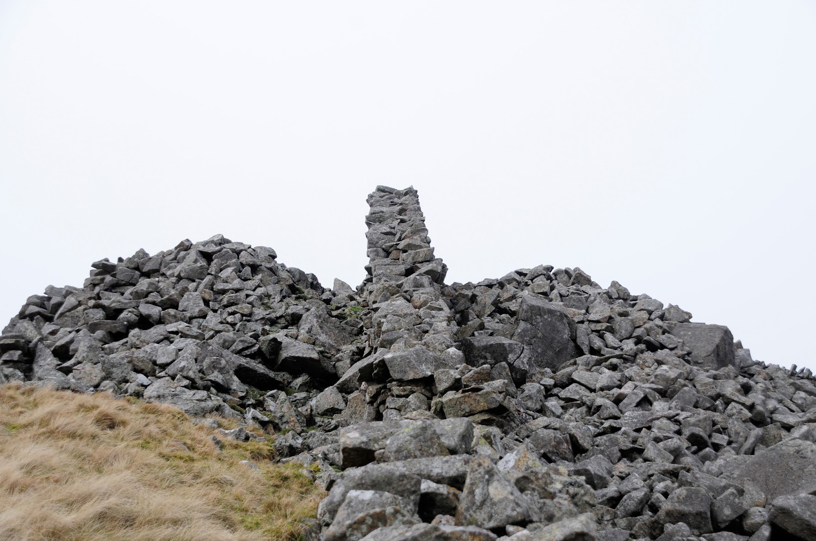
The cairn on the lower summit slopes of Bwlch Mawr looking across to
the peaks of Gyrn Ddu and Gyrn Goch.
Also on
this summit there were what looked like the remains of Bronze Age burial cairns
and dug into the cwm between here and
the next summit of Gyrn Ddu are the remains of Clawdd Seri a raised dyke which
is mentioned in local records as far back as 1200 but probably again dated from
the Bronze Age. The whole area seems to be covered in the remains of long lost
settlements.
Wall builder’s shelters?
After gaining the summit of Bwlch Mawr and doing
a bit of exploring amongst its very rocky summit I headed along the wall to
gain the next peak, this wall is a spectacular affair and is as straight as an
arrow for a good mile, nothing gets in its way and it doesn’t deviate at all
even when it confronts a pile of rocks but just carries on over and through
like a knife slicing its way through the hillside. I was aiming for the lower
summit of Gyrn Ddu and I did attempt to a shortcut across the moor to try and
make a bee line for the gap in the wall and then straight up the hillside,
after fighting my way through bog and tufts I could see why the path followed
the wall for most of its length and I returned to the original track after a
short deviation, the path here also becomes a section of the Lleyn Coastal Path
before it breaks away to skirt the base of Gyrn Ddu before heading to Trefor
and The Rivals and beyond.
The short section of
‘double wall’
On reaching a turn in the wall you are suddenly
confronted with a short section of double wall as in a drovers track, this
section has no relevance to the rest of the walls which are all single and
high, this section is no more that 100 meters in length and ends as suddenly as
it begins, another mystery!
From here you head up the path towards the lower
summit of Gyrn Ddu where another wall heads off into the distance, as it reaches
the lower summit is rather dramatically rides defiantly over the very centre of
a huge burial cairn and undoubtedly the wall builders utilised the material
available that was close at hand.
The lower summit of Gyrn
Ddu where the wall slices its way through the Bronze Age cairn
A
slight wind got up and flurries of snow began to fall, between the two summits
are more signs of human habitation in the form of the remains of a dwelling,
there is not much left but it seems to have been a single roomed house or
‘hafod’ the Welsh word for a summer shelter, where shepherds would remain with
their flock during the summer seasons, I contemplated stopping here for a brew
and a quick bite to eat but felt rather isolated but not quite alone.
The remains of the ‘Hafod’
between the summits of Gyrn Ddu
I quickly reached the summit which is very
rocky and reminiscent of the Glyderau and their boulder strewn summits and
decided it was time for some nourishment, I dropped down to the lee side of the
wind and brewed a cup of tea and ate my sandwich, I also had the comfort of the
sea view which was a respite after all the walls and moorland. The next summit
was Gyrn Goch and was the final top on the tour, it was a pleasant slope along
another wall, this wall had an alarming lean of about 70° for its whole length
and had obviously been constructed purposely in this way, possibly to act as a
deflection to the gales from the sea and not a barrier against them, but it did
give some shelter from what was now a biting wind, this was a pleasant little
summit and again not a sound, no bird song or bleating sheep or the bark of
dogs from the village way below
The great leaning walls of Lleyn
The silence was overwhelming until the ghost
stones whispered into the winds as I finally faced the final slope and headed
for home I wondered how much life was entwined in these now deserted hillsides,
there were bronze age burial cairns, ditches and dykes from the dark ages, long
abandoned farmsteads and field systems and the long oh so long dry stone walls
that dominated the landscape slicing their way over the moor and rocky summits
without as much as a slight avoiding turn till they veered off, mostly at a
perfect 90° angle and headed off up another slope to create another boundary.
Will I return to this open and sky wide expanse
of hillside again? To that I can positively say yes and fairly soon too but on
a blue sky day with the sun shimmering off the waters of the bay and Skylarks
and Ravens diving and tumbling and I will make sure that I have company other
than the ghost stones and their long lost souls whispering to the wind.
Looking across to Gyrn Ddu
from the final summit on the round, Gyrn Goch.
**The
Baron had his residence, Plas Glynllifon only a few miles away from these moors
and guarded his lands for his own use; it is only in recent times that the area
has become accessible with the advent of the CRoW* act and is now open access
land, long may it remain so.
(*Countryside
and Rights of Way Act, 2000)
The peaks of The Lleyn Peninsula on a spectacular evening.